Author Archives: Guy Cowley

The digital environment for elearning – is this as good as it gets?

I am reflecting here on the state of the digital environment for elearning – to what extent we could regard our current provision as the best we are likely to have, given warning signs for the future.  Issues of access for impaired students to web based learning and the freedom of learners to express their views on a free web form the core of the consideration.

My views are summarised in the diagram below and the ideas are developed in the audio commentary.  A transcript of the commentary is also attached.

Artefact V2

Audio commentary: Click the start arrow to play –

 Transcript – The digital environment – is this as good as it gets

#edcmooc – It’s not the technology, it’s me!

Reflecting on the first two weeks of EDCMOOC, we have seen many views of technology – broadly split into idealistic/utopian or fearful/dystopian views of the impact technology might have on our lives.  In too many of these views however, the user is shown as a follower – either as a happy and fulfilled user, mindlessly following a tech-led path or as a helpless victim, exploited by the negative controls imposed through technology.  Even in Week 3, which is about being human within a digital culture, there are still follower elements – “…in the debate about the implications of digital..technologies, what (and who) will define authoritative notions of normative, exemplary, desirable humanity…” (Graham, 2002).  We seem to be looking for someone else to define what is our appropriate positioning in respect of technology.

My graphic for the Week 3 competition suggests that it is all about us – how we behave and whether we choose to use technology as a facility to help us to improve, or whether we allow ourselves to be seduced and diminished by merely indulging in it.  Sitting at home, outside an organisational context, I feel enormously enabled by technology. It allows me to feel part of a network of people who will support my intellectual development (and I hope they feel the same!).  This does not come for free however, it requires effort and thought and a conscious positioning with technology and applications which makes them likely to contribute positively to personal growth.

Slide1

(click on the picture for a larger image)

#edcmooc – Early thoughts

My experience in studying elearning has been interesting but non-productive to date.  Having failed to introduce ICT and elearning successfully while volunteering at a school in Tanzania, my ambition has been to find out how to succeed.  However, most of my study so far has focused on Higher Education rather than schools or required a level of teaching experience which I don’t have.

My observation in Tanzania however, was that teachers were keen to get onto Facebook and pupils were keen to play games – so there was an interest in digital culture, just not in formal elearning.  Part of the problem is the didactic nature of African school education – which doesn’t recognise interaction, enquiry and fun as part of the learning experience.

So, I have hopes that approaching elearning from the broader perspective of digital culture may be a route I can develop.  I can’t hope to change the culture of African education overnight but maybe I can try to lead digital explorers into more intellectual enquiry hence, at least vicariously, towards learning. In Africa, capability is often recognised as a de facto qualification for lower level jobs, hence those able to demonstrate digital literacy may be able to climb the ladder of employment, even though not as advantaged as those who have the approved examination certificates.

Open Research: Reflecting on Open

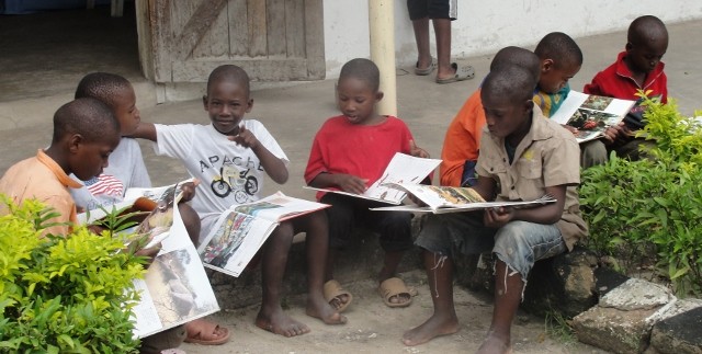
I am not a researcher, I am a failed implementer. I tried to implement a technology-based learning approach in a Tanzanian school and failed miserably – both in impact and sustainability. Failure is valuable because it gives you a sense of purpose not to repeat the same mistakes.

Part of my ‘reflection’ on that experience was to take the OU Masters in Online and Distance Education – to understand what I did wrong and might do better. That experience highlighted several things:

  • The value of interaction via forums and synchronous sessions in developing broad learning
  • The misfit between narrow, prescribed theories and broad, diverse realities
  • How little academic research interacted with fieldwork being carried out by e.g. NGOs
  • The importance of getting practical value, not just research value from projects

How is this relevant to Open Research and Reflection? I confess that I am seeing this through the perspective of an implementer rather than a conceptualiser. That means finding an 80:20 solution attractive rather than imperfectly defined! I guess it also means that I would rather see money spent on research focused on likely value (ultimately, not immediately) rather than on academic purity.

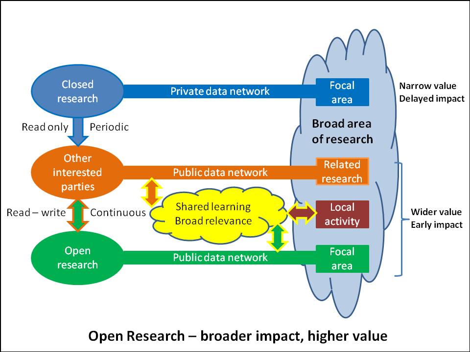
The graphic below (click on it for a larger image) tries to show how Open Research is more likely to meet my value criteria than conventional academic research.

Impact of Open Research

The graphic highlights that Open Research has a wider boundary and impact than just other researchers. “Open” means open to other interested parties such as NGOs, local researchers and local authorities needing guidance. This need not compromise the research – just as researchers use demographic data published by government authorities, so government authorities may use data generated by researchers in supporting their policies and financial commitments. Participation with NGOs seems a vast under-tapped source of data, because NGOs work on a scale impossible to imagine for an academic research team. I accept that many NGOs are themselves closed (and to some extent competitive) and may need lessons in the value of openness!

TESSA (Teacher Education in Sub-Saharan Africa) appears a good example of the sort of open research which adds real value. Based on open resources (OER), self-publishing (of at least some) research results, working with and through local universities, targeting localised solutions in areas of real need – all these seem to be a beacon of good practice in terms of the added value of academic research.

Activity 4.5.2

My interest is in development education, such as in sub-Saharan Africa, where penetration of ICT to support education is low. The challenges here are:

  • Low IT skills for teachers
  • Poor/expensive internet access
  • ICT taught as a subject rather than used as a curriculum tool

These problems require a managed, local ICT solution because the skills and/or access are not sufficient just to access open tools on the internet.

For a remote primary school in a development environment, I would invest in:

  1. An internal solution with the external internet used for extra information, not as the prime source. This internal solution would comprise a server equipped with a Learning Management System to organise access to learning materials. These learning materials would include:
  • Navigation and skills learning packages to help teachers become competent in operating computing equipment and navigating the LMS.
  • Pedagogic guides to illustrate how educational software can be used to support teaching and learning. These would be linked to specific areas of the local curriculum.
  • Educational software to support local curricula. Because of language issues this software may need to be developed or amended specially e.g. by a local tertiary education establishment. The software would include dictionaries and encyclopaedia to allow search and enquiry.
  • Educational games to allow skills to be developed in an informal way


2.  It is unlikely to be economically feasible to provide tablets or laptops to all teachers and
pupils (constraints of electricity and internet access means such personal machines would
not be used effectively). I would equip one or more “teaching rooms” which subject teachers
could book to include ICT in their teaching. The equipment would comprise:

  • Projector/Interactive whiteboard, connected to the server/LMS
  • Individual access equipment. Depending on the local environment (power, security etc) these could be desktops, laptops or tablets.

This equipment would not be useful without support – both start-up and ongoing. Part of the investment would be in initial training both of support staff and teachers and in ongoing support (maybe regionally) to provide maintenance and guidance.

Rubric for learning object – Activity 3.5.2

Rubric for Geography mapping project (based on http://www.rcampus.com/rubricshowc.cfm?code=W6B2AW&sp=yes&)

 Criterion / Level Beginning
(1)

0 pts Level 1
Approaching (2)
1 pts Level 2
Meeting
(3)

2 pts Level 3
Exceeding (4)
3 pts Level 4
Orienting map, finding current location Unable to locate North

Unable to orient map

Unable to identify current location

Able to locate North

Unable to orient map and/or identify current location

Able to locate North

Able to orient map

Able to identify current location

Able to confirm orientation and location by relating observed objects to map
Navigating using map Unable to navigate Able to make guesses about direction but trial and error and many mistakes Generally correct in predicting navigation Always correct in predicting navigation
Identifying physical object, relating to map symbol, photographing object and labelling the photograph Not able to relate physical object to map Relates physical object but without relevant detail Generally observes key features of object relevant to symbolic representation Looks for and identifies key distinguishing features of objects
Notes of aspects of location – what the map did and did not show No notes or poor notes Partial notes Good notes Excellent systematic notes
Contribution in class feedback, evidence of understanding of value and limitations of symbolic map. No contribution Partial contribution Good presentation of relationship between symbols and physical features Excellent presentation of relationship between symbols and physical features
Contribution to group task in creating new map Little or no contribution Limited contribution Valuable team member Intellectual team leader
Behaviour and proactivity Only followed or disrupted process Limited contribution, passive Good contribution, proactive Leadership role


Learning object for Activity 3.4.4

Geography – Project – Interpret a map, create a map.

Target learning

Achieve the mapping requirements of KS1 or KS2 for the UK National Curriculum.

KS 1

  • use simple compass directions (North, South, East and West) and locational and directional language [for example, near and far; left and right] , to describe the location of feature s and routes on a map
  • use aerial photographs and plan perspectives to recognise landmarks and basic human and physical features; devise a simple map; and use and construct basic symbols in a key

KS 2

  • use the eight points of a compass, four and six – figure grid references, symbols and key (including the use of Ordnance Survey maps) to build their knowledge of the United Kingdom and the wider world
  • use fieldwork to observe, measure , record and present the human and physical features in the local area using a range of methods, including sketch maps, plans and graphs, and digital technologies

Equipment

Students have tablets with detailed map and compass apps, a camera and an app to capture notes and comments.

Pre-project presentation in class

  • What is a map – show satellite and map versions of same location
  • Illustrate the concept of symbols representing physical objects in a standardised way – show on electronic map
  • Compass directions/map orientation
  • Scale – how the map represents distance

Project

Best located where there are a variety of features within a small area. e.g. in a country village

  • Provide an electronic map without symbol key but with location indicator
  • Provide an electronic compass
  • Provide numbered tags on the map at certain locations – e.g. a road junction, a railway station, a hill, a church with tower, a river, parkland etc – but without naming them.
  • The pupils orient the map, then navigate using the map to each location, following their progress with the location indicator and making decisions on navigation. They photograph and describe each location and link it to the symbol on the map. They try to interpret how the map shows physical objects – hills/contour lines, bridges over, major and minor roads, footpaths.
  • The pupils pace out a distance on the map to try to demonstrate scale.

Feedback in class

Pupils describe what they saw and what the map showed for each object. They are encouraged to interpret and analyse:

  • Which road has priority (major roads and minor roads)?
  • Does the map give permission to enter (does it show no entry signs, private property)?
  • Is the map up-to-date (maybe a building has been demolished)?
  • How steep is the hill (contours and spacing)?

Group work in class

  • Draw a map of the location of the school showing buildings, roads, special features, neighbouring buildings or land

Fit with Bloom’s taxonomy

Evaluation Evaluating what the map can and cannot show, the interaction between scale and level of detail, using a map without electronic location by observation.
Synthesis Creating a new map using learnt symbolic representation
Analysis Interpreting symbols of degree e.g. major and minor roads, contours and their density. Assessing distances using scale of map.
Application Fieldwork using maps, location identifiers, navigation, matching of symbols on the map to physical objects.
Comprehension Understanding that the symbols are a codified and not complete representation of the picture.Understanding how to orient the map in line with measured compass directions. Understanding concept of scale.
Knowledge Observing the representation of an overhead picture by symbols on a map.Reading description of compass directions and their relationship to the map.

Types of learning

Important that learning the technology does not dominate time available.

Discussion allows differences, collaboration requires those differences to be resolved

Production encourages effort to provide a good solution

Design is a key teacher input, using the technology to support the desired learning

Reflection on Davies

Conflict as ‘ethnocide’ a denial of education.  Links between masculinity and conflict.  Conflict maintained by education reproducing the status quo.  Gender parity playing a role in state stability.

For education to have transformatory value it has to clean up its act and stop reinforcing causes of conflict e.g ethnic and gender stereotypes, acceptance of unequal opportunity.

Useful for validation or challenge of some assumptions re the intentions vs outcomes of development education.

Reflection on Samoff

Development education as a reflection of donor politics and a mechanism for social control.  Winner politics (e.g. USA in post cold war world) – no need to listen.  Local education authorities reduced to marketers of opportunities in such terms as to attract conditional funding.  Connected world does not democratise information since most of it is sourced within the prejudices of the North.  Little evidence of attempts to develop critical faculty or citizenship or other nationally valuable skills.  Tendency to reinforce established formal structures which perpetuate elites.

Generally destructive of established assumptions and challenging rather than offering an alternate point of view.